Because a lot of the terrain in Utah looked very similar it was dicey getting the pictures separated and labeled (remember, I was taking photos with my camera, my phone, my Tablet, and Gary was taking pictures with his phone!!!), and I still can't guarantee that there might be a mix-up especially with this blog on Capitol Reef and Grand Staircase-Escalante! Let's just go with it, though, and pretend like it's all working out perfectly, okay? And if I duplicated in a picture in either of the blogs ... so sorry, scroll quickly!

So, how does that "Gorilla" work? Here I am setting up the Gorilla on the Jeep side mirror to take our photo! It's the vacation paparazzi at work!

Our drive to Capitol Reef produced a "surprise" for us. We needed to pullover for Gary to stretch and give Sadie a potty break. This looked like a great area for some of the cool hoodoos we saw, but the surprise was hearing someone shout and holler and then zooming into see where they were! See that hoodoo on the left?

Here's what was on top of it! Can you see him? Makes me shiver just to think about it!

How about these views from our RV?


The mule deer population abounded--you would have thought they were rabbits! One morning when Gary was walking Sadie they saw over 20 deer grazing in one of the open areas. They meandered around the campground without a hunter care in the world!


The park is characterized by sandstone formations, cliffs and canyons and a 100-mile long bulge in the earth's crust that stretches across south-central Utah. This vast warping of rock, created by the same great forces later uplifting the Colorado Plateau, is called the Waterpocket Fold. Capitol Reef National Park preserves the Fold and its eroded jumble of colorful cliffs, massive domes, soaring spires, stark monoliths, twisting canyons, and graceful arches. But the Waterpocket Fold country is more than this. It is also the free-flowing Fremont River and the big desert sky. It is cactus, jay, lizard, jackrabbit, juniper, columbine, and deer. The world of the Waterpocket Fold stretches 100 miles--and beyond!
We took the Scenic Drive from the Campground to the end with a side trip down a couple of washes along the way.


How's this for a warning? It was cloudy. Gary was nervous. We didn't go very far in this wash!


This is Chimney Rock.


More hoodoo.


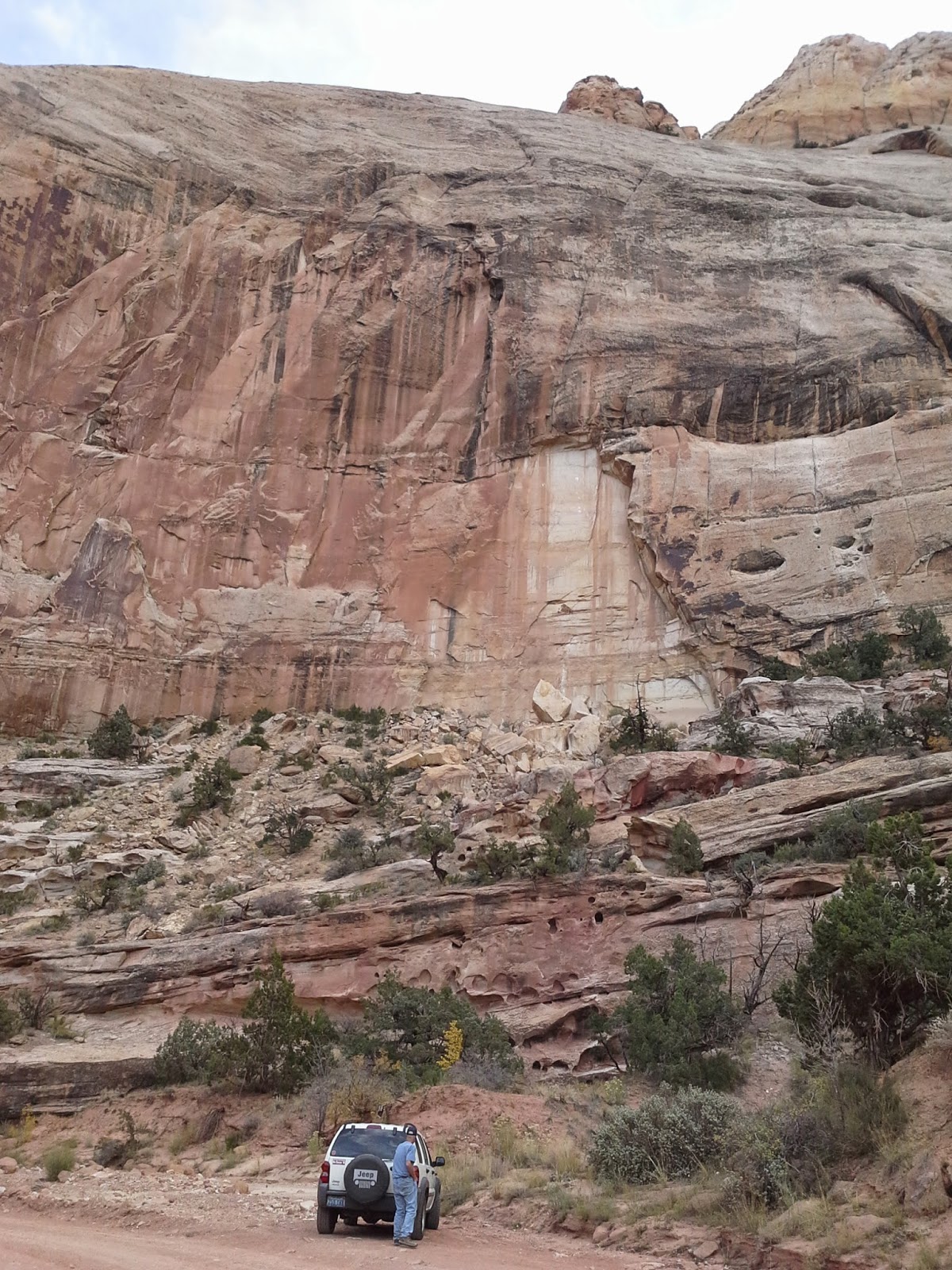
These photos are from the Capitol Gorge Road which we took to its end (regardless of the same warning that we saw for Grand Wash). I got Gary to throw all caution to the wind ... and we made it! I call this first one the weeping rock. We saw a lot of "weeping rock" in and around the different National Parks/Monuments in Utah.


To give you some perspective on how high these towering walls are. There's Gary and the Jeep in the very bottom of the photo.


I call this rock formation the snapping turtle.


Now for more red rock, solitary sandstone monoliths, sweeping panoramas and wild beauty (as if you haven't already had enough!).

I love the way the sun shone through the clouds highlighting the rocky plateau.


This is Eph Hanks Tower which is really the north end of a long ridge. It is named for Ephraim Hanks who was a notable Mormon pioneer. Hanks traveled across the country from Nauvoo, IL to California, partway with the Mormon Battalion of the United States Army. He also served as a Station Master for the Pony Express, facilitating mail delivery near Immigration Canyon in Northern Utah. He is buried near his home in Caineville.


Psalms 61:3-4
For You have been a refuge for me, a tower of strength against the enemy. Let me dwell in Your tent forever; let me take refuge in the shelter of Your wings. Selah.


