Hey blog readers/friends, I just looked at my "Day with Raul" blog and it was all messed up, so I completely redid it. Same photos and most of the same verbiage, but I believe you can now read it with the type color all in white.
Feel free to enjoy it again!
Tuesday, February 24, 2015
Volcanos and Equators (Formerly Our Day with Raul)
Michael and Erica procured a tour guide for us for the day--Raul. We really enjoyed him and all the information he shared during the course of our tour. We made three stops: Reserva Geobotanica Pululahua, Mitad del Mindo (the "historic" equator), and Inti-Nan (Path of the Sun) Solar Museum (the "real" equator).


The road from Quito to Latacunga and Ambato and then to Cuenca is the Pan American Highway which runs through a long, fertile, central valley sometimes known as Volcano Alley. On either side of the valley rise parallel sets of mountains (the east and west Andes) with nine of the country's highest peaks. The volcanos include (listed north to south) are: Imbabura, Cayambe, Reventador, Pichincha, Chacana, Antisana, Sumaco, Cotopaxi (we did visit Cotopaxi National Park and that will be the subject of our last Ecuadorian blog), Tungurahua and Sangay. On the map below of Volcano Alley Quito is the green dot.


 Here's a photo of Gary and me on the path to the monument which you can see in the middle of the photo. You can also see more of these busts that line the pathway.


Volcanos
Let's start with the Pululahua Volcano. Pululahua is an inactive volcano but its past eruptions (the last one around 2,500 years ago) left a huge crater full of fertile soil. Sitting at 11,549 feet, the volcanic crater is one of the largest in the world. The lava dome in the middle rises 1,640 feet above the crater floor and is covered in lush cloud forest vegetation.
Pululahua is one of only two inhabited volcanic caldera in the world and the only one cultivated by its inhabitants. It is believed that it was first settled by the Incas. The small agricultural communities here grow various crops in the rich soil of the fields around the crater floor.
Pululahua is Quichua for "Smoke of Water" or "Cloud of Water." This probably refers to the fog or "neblina" which rolls in around midday every day and fills the crater. As you can tell from the photos below, we were there (obviously) in the morning! The fog is the only real source of water for the crops cultivated here because it virtually never rains at Pululahua. The crops thrive in the fog, but tourists ... well, they generally don't!The road from Quito to Latacunga and Ambato and then to Cuenca is the Pan American Highway which runs through a long, fertile, central valley sometimes known as Volcano Alley. On either side of the valley rise parallel sets of mountains (the east and west Andes) with nine of the country's highest peaks. The volcanos include (listed north to south) are: Imbabura, Cayambe, Reventador, Pichincha, Chacana, Antisana, Sumaco, Cotopaxi (we did visit Cotopaxi National Park and that will be the subject of our last Ecuadorian blog), Tungurahua and Sangay. On the map below of Volcano Alley Quito is the green dot.
Here we are at the crater's edge.
Mitad del Mundo
After leaving Pululahua, we headed to Mitad del Mundo. The equator actually runs all the way around the earth, but you could be forgiven for thinking it was just one point in Ecuador. The Midad del Mundo ("Middle of the Earth") complex just outside Quito is heavily promoted as being the equator. In fact it is a tourist trap built around a monument to an expedition from the 1700s which located the equatorial line with impressive accuracy for the time, but which later technology has revealed to be about 787.4 feet off the mark.
At the entrance to the monument you are greeted by this row of flags. I didn't really look to see if the flags were representative of the countries that were involved in the expedition. However, from the number of flags I'm thinking they may have been.
These busts line the path to the main monument. They are different scientists from the different countries who were responsible for calculating the location of the equator. It took them (approximately 20 of them) seven years to line up the stars and the different mountain peaks which resulted in their identifying the location of the equator. This location held until the invention of GPS which located the equator a little more than a quarter mile away. I guess not too bad for 20 men and seven years!
Our guide, Raul, took this photo from a second story balcony that faces towards the monument.
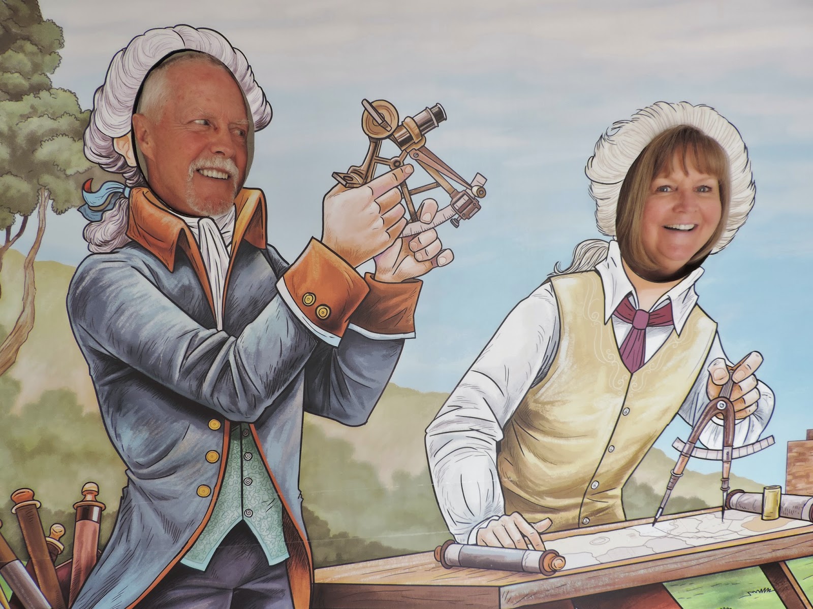
This picture was taken inside the Ecuadorian Exhibition at Mitad del Mundo. We're having fun now! And you can see examples of the types of instruments used to identify the equator location, too.
Inti-Nan (Path of the Sun) Solar Museum
The quirky little Inti-Nan Solar Museum just up the road from Mitad del Mundo claims to lie exactly on the equator itself, though this is not actually true either according to people who have checked with GPS (however, we did not see or hear anything that refuted the equator claim). There is also a bizarre collection of totem poles, pickled snakes, models of traditional houses, blow-pipes and a supposedly genuine shrunken human head.
Inti-Nan is a lot more fun that Mitad del Mundo with "demonstrations" of various equator-and solar-related phenomena, at least some of which are faked (we didn't see anything that remotely seemed fake), and a certificate if you manage to balance an egg on a nail. We did see some of the people in our group actually accomplish this feat.
Here are some of the buildings that are scattered around the entrance area. This place is not as professionally architecturally designed as Mitad del Mundo, but we sure enjoyed it a heck of a lot more.
We really liked this sign in the pavement ... Jehovah is my rock!
Here we are walkin' the line with our feet straddling the equator--north and south sides. Hey, if you're not careful, I'll start singing the Johnny Cash song, "Because You're Mine, I Walk the Line", but I'll spare you this time!
Here's PROOF POSITIVE that we're in the middle of the world ... can't dispute a sign, can you?
This was one of the non-scientific equator experiments they conducted at Inti-Nan. You close your eyes, hold out your hands, and then try to walk a straight line right on the equator. Not one person who tried it was successful ... especially Gary who already has a balance problem. But he did give it the good ole college try.
As mentioned in my preface to Inti-Nan, here's a sampling of the bizarre totem poles on display.
Now, having seen both sites and hearing how they "discovered" or identified the equator, Raul told us of one last equator location discovery and that was made many, many years ago (before the 1700s scientific expedition, who pooh-poohed the indigenous people's equatorial identification) and that was the identification by the indigenous people that just so happened to match the coordinates of the GPS equatorial location. Here's a picture of the "monument" to that site. I don't think many people go up there to visit as there really isn't much to see ... except maybe that single, lonely pole.
On our way out of Inti-Nan I bought my Mitad del Mundo satchel (you can see that colorful satchel in some of the pictures of Gary and I above). A lot of Quito citizens use these satchels which are very handy. I loved mine because I was able to carry my wallet, camera, and other miscellaneous items all in one place instead of carrying separate items, like my purse and camera case. It also came in very handy for carrying around my toilet paper ... that's right, I said toilet paper (or TP for short).
"Why carry toilet paper?" you ask. Well, there are a number of public bathrooms in Ecuador that may not have TP ... that's right, nothing to wipe the old bum with! So, here are the different TP availability options I came across in Ecuador:
(#1) TP would be in the stall, available only in the finer establishments and malls.
(#2) TP would be available at no charge on a roll right outside the bathroom entrance. With this option, you needed to remember to dispense yourself some TP before entering into the stall to do your business.
(#3) TP would be available either inside the bathroom or outside at the bathroom entrance for a fee--cost of 10 cents to dispense one of these handy-dandy TP packages all nicely folded inside a blue paper wrapper (see below). YUP, you had to pay to pay to wipe!
(#4) There was no TP at all.
And that's why I always used only half of my purchased TP package at a time and saved the rest securely in my satchel ... you just never knew when you were going to encounter Option #4 and you always wanted to be prepared!
Psalms 18:31
For who is God, but the LORD? And who is a rock, except our God.
Monday, February 23, 2015
Parque La Carolina & Jardin Botanico de Quito
Parque La Carolina is a 165.5 acre park in the center of the Quito main business area, bordered by the avenues Rio Amazonas, de los Shyris, Naciones Unidas, Eloy Alfaro, and de la Republica. This park started from the expropriation of the farm La Carolina in 1939. The design of the park was made by the Direccion Metropolitana de Planificacion Territorial.
Here are my two granddaughters and son, Michael. Romy (on the monkey bars) is 5-years old. She can go back-and-forth on the monkey bars a number of times on her own. She's been amazing on playground equipment for years. Malin (right below Romy) is 3-years old. She's not too far behind Romy is her athletic playground skills.
 Malin can't quite do the monkey bars on her own, but she's in the process of learning with dad's help.

 If you have kids, you know how different they can be from each other. Both came from the same place, raised by the same parents in mostly the same way BUT so very different. The picture below is a great example of how different they are. Malin probably already has her ice cream in hand and just grabbed whatever. Romy, on the other hand, is precariously positioned on the side of the portable ice cream cart trying to figure out just what ice cream she really wants today, reviewing them one at a time!
 Within Parque La Carolina is a very large water lake with boats you can rent. It was a beautiful day and the park was packed. So much stuff going on everywhere including individual performers displaying their talents for all to see, admire and possibly pad their pockets and food vendors galore. You could experience it all at Parque La Carolina!

 Located in the southern sector of Parque La Carolina, north of the city, sits Quito Botanical Garden. Ecuador is one of the countries with the greatest plant diversity per area of the planet; this is because this small country has classified 17,000 plants (more species than the entire European continent). That means in Ecuador you can find around 50,000 species of plants! That's why Quito Botanical Garden makes every effort to preserve as many Ecuadorian species as possible.
The Botanical Garden has an area of 195,903 square feet. It offers different areas where the flora is divided into diverse climatic zones that the Ecuadorian highlands have, in addition to the permanent exhibits of plans with specific characteristics, and warmer region plants which are found in the greenhouses.
These climatic zones are: the wetlands, the Cloud Forest and Moorland. There is a greenhouse where there are several plants of the Amazon region; there are themed gardens which exhibit roses, lilies of the valley, bromeliads, palms, important plants for their characteristics and use.


Here are my two granddaughters and son, Michael. Romy (on the monkey bars) is 5-years old. She can go back-and-forth on the monkey bars a number of times on her own. She's been amazing on playground equipment for years. Malin (right below Romy) is 3-years old. She's not too far behind Romy is her athletic playground skills.
And here's Romy slipping down the slide and enjoying every second of it.
The Botanical Garden has an area of 195,903 square feet. It offers different areas where the flora is divided into diverse climatic zones that the Ecuadorian highlands have, in addition to the permanent exhibits of plans with specific characteristics, and warmer region plants which are found in the greenhouses.
These climatic zones are: the wetlands, the Cloud Forest and Moorland. There is a greenhouse where there are several plants of the Amazon region; there are themed gardens which exhibit roses, lilies of the valley, bromeliads, palms, important plants for their characteristics and use.
Here are my darling granddaughters posing in front of the koi pond. Romy is on the left and Malin is on the right.
Grandpa, Grammy and the two darling granddaughters.
This is a huge painted wall in the Botanic Gardens ... a perfect photo opportunity for two darling granddaughters!
Two darling granddaughters hammin' it up for Grammy!
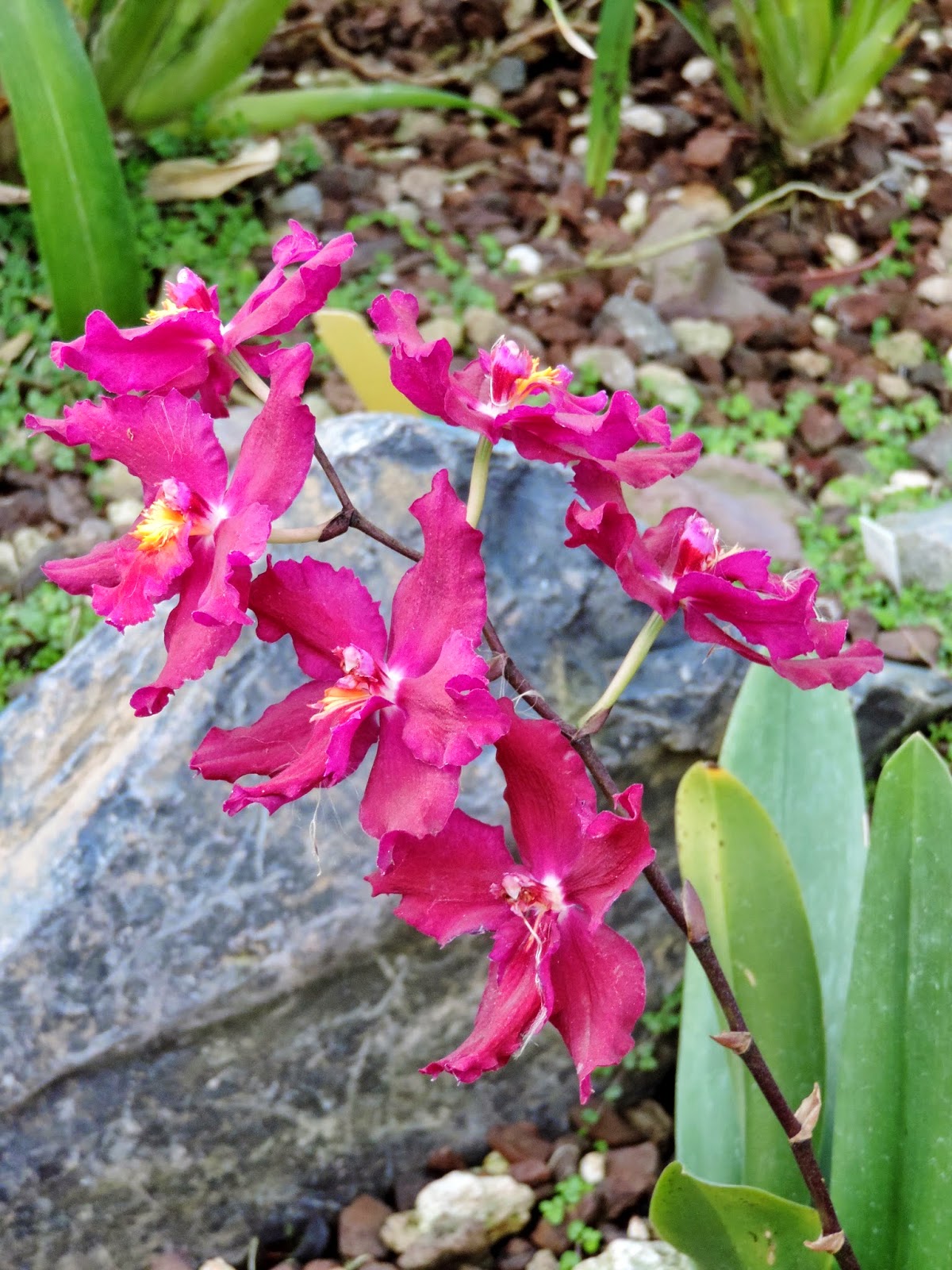
The exhibit that is their highlight of the Botanic garden is the orchid exhibit. With 4,250 classified orchid species, Ecuador is considered a country of orchids. Quito Botanical has the largest orchid collection on public display in South America. I didn't get names for any of them so what you're going to experience next is just a series of MANY orchid photos. They are amazing, beautiful, and well worth the visual tour. Surely a delight to the eyes.
Michael and the darling granddaughters in the orchid exhibit.
A beautiful bromeliad.
Did you ever think so many different varieties and colors of orchids even existed? God is one amazingly creative designer! But wait, there's more!!!
Another special attraction is the exhibit of carnivorous plants. They not only feed on insects, as most people think, but they can also trap and digest small amphibians, fish, worms and rodents. A space called the health in different cultural contexts, especially in the Amazonian tribes.
Outside the exhibits were these two really interesting looking cacti plants.
Father and son ... see any resemblance?
This is my lovely daughter-in-law, Erica, and the two darling granddaughters again. Erica is pregnant with granddaughter #3 and is due late April. I'm not sure I'll be able to keep up with three granddaughters ... two was a handful and I was often exhausted from playing. Now I know why God designed younger women to have kids and not older ones ... we just wouldn't make it I'm afraid!
More flora in the garden.
Here's this flower getting ready to bloom.
And here's what it looks like fully opened up blooming. Cool, huh?
And these cool metal insects hanging around the trees.
Isaiah 40:6b-8
All flesh is grass, and all its loveliness is like the flower of the field. The grass withers, the flower fades, when the breath of the LORD blows upon it; surely the people are grass. The grass withers, the flower fades, but the word of our God stands forever.
All flesh is grass, and all its loveliness is like the flower of the field. The grass withers, the flower fades, when the breath of the LORD blows upon it; surely the people are grass. The grass withers, the flower fades, but the word of our God stands forever.
Subscribe to:
Posts (Atom)