Wednesday, September 30, 2015

Back to Glacier

It's smoke-free ... YAHOO!!!!  Finally, the smoke from all the Pacific Northwest fires has been washed away by the recent rains and we can finally see and breathe again.  That also meant it was time to head back to Glacier National Park again and this time we would have some magnificent views of the countryside.  We were not disappointed!  First stop, Lake McDonald.

This is the boat they use for the Lake McDonald boat cruise.  They're loading passengers to take flight.
 
Lake McDonald Creek that (surprise! surprise!) flows into Lake McDonald.
 
After leaving Lake McDonald, we decided to stop at Belton Chalet that is located just outside the west entrance to the park.  There area  group of these buildings in the village of West Glacier that were built by the Great Northern Railway between 1910-1911.  The buildings featured a "Swiss Chalet" architectural style that set the style for much of the Great Northern's building program in Glacier.  Ultimately, the site included five buildings, including a dining hall and a hotel facility.
 
 
Some of the flowers blooming in abundance around the grounds.

Not far into our journey we were blessed beyond belief.  Having just passed Lake McDonald I jokingly said to Gary, "Wouldn't it be great if we saw a moose run through the river?"  No sooner were the words out of my mouth when we rounded a curve and there were all these people pulled over at the side of the road gazing at a moose on the other side of the river!!!  Oh me, oh my!  Could I ask for anything more?  NO!!
Me, photographing the moose.
More moose!
 
Photos taken at Logan Pass ...
 
Below is one of the glacial horns at the Visitor's Center at Logan Pass.  A pyramidal peak--sometimes in its most extreme form called a glacial horn--is an angular, sharply pointed peak which results from the cirque erosion due to multiple glaciers diverging from a central point.
 It was a bit chilly, thus the jackets
 
These next photos were taken along the Going to the Sun Road.


Birch trees ... I love the look of Birch trees.
On the east side of the park, by St. Mary Lake, that's where the worst fire was and in the pictures below you will see just a glimpse of the devastation caused by that wildfire.  That's St. Mary Lake peeking through the burned brush.


St. Mary Lake is (as you can see below away from the burn area) a beautiful alpine lake.  It is the second largest lake in Glacier National Park.
 
 
From here we traveled a little north to the Many Glaciers area of the park.  We had heard rumors that the bears were out in that area so we wanted to see bears!  Unfortunately, there were no bears (so sad) but we did get the3 opportunity to see Swiftcurrent Lake with Mount Wilbur in the background, and boy was it windy!
 Check out the wave action at the shoreline.
I videotaped a short segment so you could really get an idea of how windy it was.  I'll upload this video to FB because I'm still experiencing problems with my videos uploading.
Don't you love the "squiggliness" of these pine trees?

Another awesome side trip on this trip was to Falls.  We didn't even know this was on the route, but quickly took the turn at Two Medicine to get there and we're glad we did because it was a beautiful area.
 Here's Gary on the trail.  We really enjoyed our stroll through the forest.
 
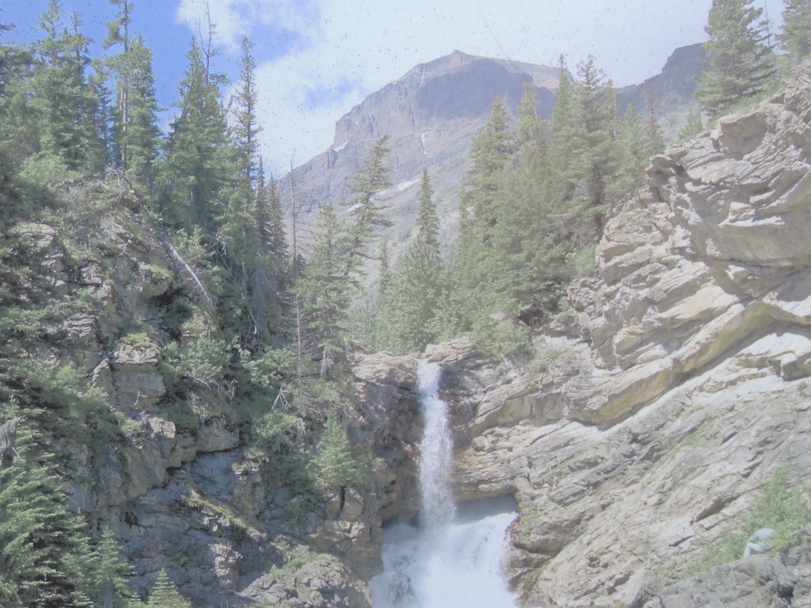
And this was our intended destination, Running Eagle Falls.

 
The falls were not in full flow.  I took a picture of a picture that shows what they look like when they're really in full flow.
Some of the beautiful color change in process.

Another Continental Divide crossing added to our lengthy list!
From this point on in our loop drive, we were outside the park property.  Our next stop was this memorial. This is the John F. Stevens Memorial Statue.  John was an engineer for the Great Northern Railroad.  He was charged with finding a suitable route across the Continental Divide.  In December 1889 he located and recorded the pass that had been used by native Indians for many centuries.


Exodus 3:15
God, furthermore, said to Moses, “Thus you shall say to the sons of Israel, ‘The LORD, the God of your fathers, the God of Abraham, the God of Isaac, and the God of Jacob, has sent me to you.' This is My name forever, and this is My memorial-name to all generations.


Sunday, September 20, 2015

Canadian Cavorting, eh?

Along with our RV park friends, Joe and Colette, we headed through Glacier National Park to Waterton National Park in Canada.  Once again, all our sightseeing was distorted by the massive amount of smoke from the numerous fires plaguing the Pacific Northwest which has the distinct privilege of being part and parcel of the Ring of Fire.  What about that Ring of Fire?  Do you feel a history lesson coming on?  Well, you should!

The Ring of Fire is an area in the basin of the Pacific Ocean where a large number of earthquakes and volcanic eruptions occur.  In a 25,000 mile horseshoe shape, it is associated with a nearly continuous series of oceanic trenches, volcanic arcs and volcanic belts and/or plate movements.  It has 452 volcanoes and is home to over 75% of the world's active and dormant volcanoes.  The Ring of Fire is sometimes called the circum-Pacific belt.  About 90% of the world's earthquakes and 81% of the world's largest earthquakes occur along the Ring of Fire.  How do you like that, you Californians?

Things were looking promising when we had a couple of wildlife sighting at Logan's Pass.  The first thing we saw (which was across from the parking lot and up the hillside) was a small herd of bighorn sheep. 
But the big "bonanza" was the bear!!

Colette took a video of the bear strolling towards one of the hiking paths ... eek!!!  By the way, I know the possibility exists that the video will not play so I'm also going to post it on my FB page and hope it works there.
But as I mentioned, the smoke was obnoxious and the burn was terrible.  The next two photos were taken at Lake McDonald and you can see how much the sun is being filtered by the smoke.
I zoomed in on the sun because you couldn't see how red it really was from the previous photos.  The zoomed-in one (below) really shows how much the smoke altered the look of the sun.
This is a shot of the burn area on the east side of the park, near Lake St. Mary. The landscape on the east side of the park has been radically revised.  In reading the local newspaper, they brought in the "silver lining" to all of this ... with the clearing of trees the views of the mountains are now magnificent because now you can see them!  Who said you can't find something good in a bad situation?  Shame on them!
And now, what you've all been waiting for ... our grand exit and then entrance ...
 
Along our route to Waterton Glacier International Peace Park, we entered ...
And, just in case you didn't really see a bear, they had these lovely roadside stand-ups for photo opportunities ... eek!!!  Below, Gary and me caught by surprise (ha!ha!).
Here's our good friends, Joe and Colette.  We are sure going to miss them after we depart, but we just might see them again next summer in Colorado!  This bear did not give them a fright ... what's wrong with them?

 The grand and glorious entrance to the park.
We thought we weren't going to see any wildlife, but silly us.  How about these "Glacier Buffalos" (as we so cleverly called them since we were desperate for any wildlife sighting in Canada) that were scattered throughout the route?
 

Our first destination was Red Rock Canyon.  The Red Rock Parkway travels 5 km up the Blakiston Valley through rolling grasslands and ends at Red Rock Canyon.  It is considered the best place to experience Waterton's classic prairie-meeting-mountain landscape (which had significantly diminished views by all the smoke in the air).  At the end of the parkway we took a short self-guided trail that looped around the canyon.
 Smoky, smoky, smoky :(
 
In this photo you can really see how smoky it is in the area from all the wildfires.  Canada also had its share of fires this summer.
Looking straight down into the canyon from the hiking trail.


These are mud cracks along the interpretative trail.  When ancient sea waters subsided, mudflats were left to dry out and crack.  As the water returned, the cracks filled up with slightly different deposits.  Later hardening to rock, the honeycomb pattern on this footpath was created.
Leaving Red Rock Canyon we decided to explore Waterton Village (located on Upper Lake Waterton) and stumbled across Cameron Falls.  But first, a little bit of this quaint town situated in the middle of Waterton National Park ...
 Gary rockin' it!
 A shot of this town.  That's Joe, Gary and Colette strollin' down the street.
 More of Main Street
And now, Cameron Falls ... These falls cascade over ancient dolomitic rocks. 
 
Sadly, I "lost" a number of photos I took today.  I don't know what I did, but some fancy finger work did the trick and they are no longer ... not even in my "trash" ... so sad :(  So, that's all for the day although it wasn't all for the day!
 
Micah 1:3-4
Look!  The LORD is coming from His dwelling place; He comes down and treads on the heights of the earth.  The mountains melt beneath him and the valleys split apart, like wax before the fire, like water rushing down a slope.