Thursday, November 6, 2014

Canyonlands National Park

Not far from Arches National Park is Canyonlands National Park so naturally we zipped on over there after our Arches visit ... but definitely not the same day!  Each of these parks is a minimum of a one-day visit or more.  If you are a hiker, then you could spend at least two or more days in each park.  Since we have Sadie with us (and dogs aren't allowed on national park trails) we aren't avid hikers anymore, although we did some great hikes in Rocky Mountain National Park.

So, let's begin by saying "Hello!" to this next national park on our Utah national park whirlwind tour!
Honestly, we really didn't know much about this park other than its strategic location next to Arches. So, this one-day tour through the park was a pleasant surprise.  The key word for this national park (as it will be for the next one, Capitol Reef) is PANORAMA.  The spectacular panoramas we saw were breathtaking and hard to catch on film.  We did our best for you (and  posterity, of course) but truly it wasn't good enough (sorry to say).  

Canyonlands preserves a wilderness of rock at the heart of the Colorado Plateau.  Water and gravity, this land's prime architects, cut flat layers of sedimentary rock into hundreds of canyons, mesas, buttes, fins, arches, and spires. At center stage are two canyons carved by the Green and Colorado Rivers.  Surrounding the rivers are vast, very different regions:  Islands in the Sky on the north, The Maze on the west, and The Needles on the east (we only visited the Islands in the Sky region).  They share a common primitive spirit and wild West atmosphere.  Few people knew these remote lands and rivers well when the national park was established in 1964.  Only American Indians, cowboys, river explorers, uranium prospectors had dared enter this rugged corner of southeastern Utah. Canyonlands remains largely untrammeled--its roads mostly unpaved, trails primitive, and rivers free-flowing.  Bighorn sheep, coyotes, and other native animals roams its 527 square miles. Canyonlands is wild America!

One of the first features before you enter the park are two side-by-side buttes the Monitor and the Merrimac--aptly named after two iron-clad Civil War ships.  The Merrimac (on the left) was named after the Confederate ship called "The Virginia" by the Southern forces.  The Monitor was the Union ship sent to destroy the Merrimac. The resulting sea battle changed maritime warfare forever.

The Monitor and Merrimac buttes are composed of Estrada sandstone, the very same that forms many of the arches in Arches National Park.  
The Merrimac
 The Monitor
Cairns are a feature in many of the Utah National Parks.  They are used by Park Rangers to mark trails.  I really liked this particular cairn.  They ask that you don't remove stones from a cairn nor move them from their locations.  They really do help establish a trail and give great direction!
One feature of the Colorado Plateau that makes it so beautiful is the many and varied colors of the rock layers. The coloration is due to the various minerals found in the rocks.  These colors react to weathering by coloring the rocks. The prominent reds and yellows in the landscape are formed when the iron in the rocks is exposed to the atmosphere.  The black sheen seen on many rocks, especially on cliff faces, is formed by manganese.  (This black sheen is called "desert varnish.")  Purples and greens are caused by clay minerals in the Morrison and Chinle formations.

Let's continue our tour through this amazingly colorful landscape.  The first stop was Shafer Canyon Overlook in the Island of the Sky region of the park.


Can you see some of the similarities between the landscape below and at Arches?
 
Our next stop was Mesa Arch ... yup, there's a great arch in Canyonlands too!
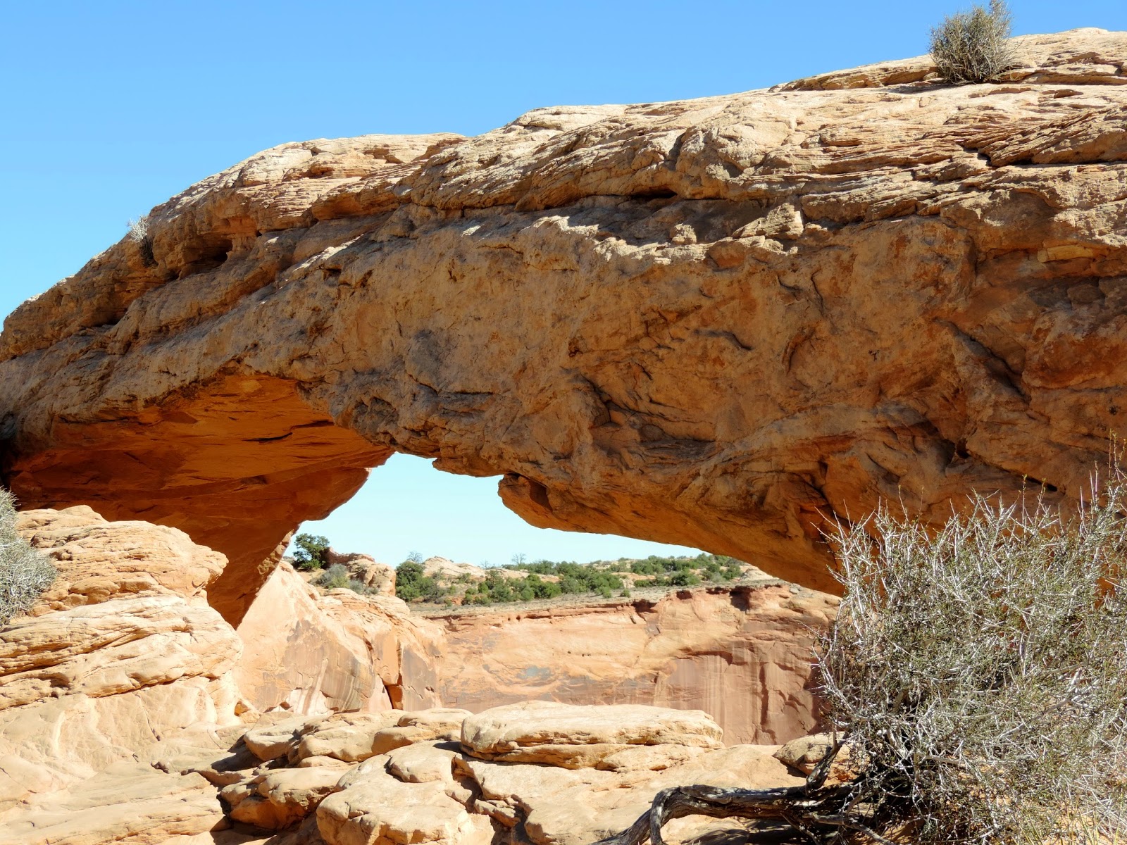
Didn't Gary get an excellent shot through the arch?  It could almost be considered a window because of the fabulous features you see through it.
This is more scenery from the Mesa Arch overlook.
 
The next stop on our journey was the Green River Overlook at 6,000 foot elevation.


Here we are waving "hello" from the picnic area after lunch.
After lunch we continued our drive to Buck Canyon Overlook.


 Yes, it's another arch!


Our last and final overlook was Grand View Point, elevation 6,080 feet.


I'll finish this blog off with a nice video panning one of the scenic overlooks -- wish I could remember which one it was, but everything seems so jumbled and out of order when mixing photos from three different electronic devices!


Psalms 104:24
O LORD, how many are Your works!  In wisdom You have made them all; 
the earth is full of Your possessions. 

Arch, window, bridge, hoodoo, spire, tower ...

Those descriptive names have been given to the sandstone features visible throughout Arches National Park and elsewhere in the southwest.  As a matter of fact, hoodoos abound in Bryce Canyon.

What's in a name?  Is an arch the same as a bridge?  How about a window?

To qualify as an official stone "arch," a hole must have an opening at least three feet long in any one direction.  There is no requirement for width, though; quite a lot of the arches in the park are so skinny you have to place your cheek up against the rock in order to see any light through them.

Is a window a special kind of arch?  Not really.  "Window" is just a descriptive term that is often given to rock openings high on a rock wall or fin.  Some arches are called windows if they "frame" a particularly good view of the landscape beyond.

Finally, what constitutes a bridge?  A natural bridge is formed by running water and spans either a present or former waterway. Very few natural bridges exist at Arches, but Natural Bridges Monument has three tremendous examples of this feature.  Unfortunately, we did not have time to go there as we were hobnobbing enough as it was already!

So, here we are at Arches National Park.  This was a beautiful, scenic, stunning, amazing, and spectacular National Park.  Actually they ALL are truly sights to see and beauty to behold in their own ways and this was just one more (of many) enchanted places to visit.
Water and ice, extreme temperatures, and underground salt movement are responsible for the sculptured rock scenery of Arches National Park.  On a clear day it is difficult to imagine such violent forces that created this land boasting one of the world's greatest densities of natural arches. Over 2,000 cataloged arches range in size from a three-foot opening (the minimum considered for an arch) to the longest, Landscape Arch (which we did not see), measuring 306 feet base to base.

Our first stop in the park was called "Park Avenue".  What a great way to start our journey through this magnificently sculpted landscape.  This photo below was from the overlook, looking left,

From the same overlook, looking right you saw the sheer walls that reminded early visitors of a big city street.  Rising majestically, these geologic "skyscrapers" tell the story of the Entrada Sandstone.  Entrada Sandstone began forming over 150 million years ago as tidal flats, deserts and beach deposits.  Tremendous pressure from these rock layers compressed the buried sand into sandstone and cracked it.  Erosion then removed the overlying rock layers and the Entrada began to weather. Within the past two million years, erosion of the cracks in the Entrada has left vertical slabs like the ones below.  These slabs, called "fins", are the first steps in arch formation.


The rest of this blog will NOT be in the order that we drove, but will be more about the location and the features of each location.  There were so many stops and so many pictures taken with my camera and our phone cameras that have to be put together that it is just too complicated.  But this wasn't as complicated as some of our subsequent park visits where I added in photos taken with my Tablet on top of the other three electronic devices.  Holy electronic media, Batman!  It's been somewhat of a nightmare trying to get organized.  Well, enough whining for one blog ... now back to the exciting stuff.

While Arches had an actual stop for a "Balanced Rock", we saw both balanced rocks and arches at just about every Utah National Park/Monument we visited.  However, here is Arches National Park's "Balanced Rock" which you may recognize from my FB post.  This feature is 128 feet high.  The boulder height is 55' and weighs 3,500 tons.  The very top rock (boulder) is called Slick Rock Member, and the rock beneath it is called Dewey Bridge Member.  The Dewey Bridge Member weathers more quickly than the resistant rock above it and eventually the faster eroding Dewey Bridge will cause the collapse of Balanced Rock.
 
Next are some great landmarks in the park and they all have "cute" names!  This first one is called "Three Gossips".  Sitting to the right of Three Gossips is Sheep Rock. Apparently at one time there may have been an arch that stretched from the Three Gossips to Sheep Rock.
On the right side of the road from the Three Gossips were these two monoliths: Tower of Babel  (left) which was connected to The Organ (right).
.This huge monolith below is called "The Courthouse".
This next series of photos is from an area called Garden of Eden.  I personally (and Gary concurs) that it should have been called Phallic Garden J.  You'll soon see why ... but it wasn't the only area of the park that could have been mistaken symbolically! 


Today new arches are being formed and old ones destroyed. Erosion and weathering work slowly but relentlessly, creating dynamic landforms that gradually change through time.  Change sometimes occurs more dramatically.  In 1991 a rock slab 60 feet long, 11 feet wide and four feet thick fell from the underside of Landscape Arch, leaving behind an even thinner ribbon of rock.

These next photos are from "The Windows".  NOW, we're getting into real arch territory.  You were probably wondering where all the arches had gone, but they have finally arrived!


Do you see the "window" to the left of this arch?
Maybe this could also be called a "window?"


The next arch is called "Delicate Arch".  We did quite a trek to see this one and Gary didn't think it was worth it although I did.  We actually took the "easy" way.  There was another hiking trail to actually get to the arch (you can see some people in our photo below), but that hiking trail was described as follows:  "3 miles.  Difficult trail with elevation gain of 480'; no shade--take at least one quart of water per person.  Open slickrock with some exposure to heights."  That description did not fit my physique!  So, we took the 1/2 mile moderately difficult, rocky uphill route which provided this photo opportunity.
This next arch is called Sand Dune Arch.  It is named for its location in a sandy slot canyon between two fins.  The sand here was particularly fine and pinkish-red in color.
This area was called "The Fiery Furnace".  Using my Tablet, I did a panorama of the area which is the first shot below.
 
 
This is "Skyline Arch".  In 1940 a large boulder fell out of the arch roughly doubling the size of the opening.  This new arch has a span of 71 feet.
The photos below are of "Petrified Dunes".  That's right, sand dunes that are now like rock! The formation was produced when ancient sand dunes hardened into stone under the overlying subsequent material, which later eroded away.  The first photo below was taken in the afternoon on our way out of the park.  The second photo was taken in the morning on our drive into the park.  Big difference in the colors, huh?
Are you getting arched-out yet?  But wait!  There's more!  The rest of the photos are from random areas of the park displaying a number of interesting hoodoo figures.  Enjoy the show!
Here's some nice "fins" for you.


Can you see Gary at the base of this hoodoo?  Wanted to give you a little perspective!
 
Talk about a balanced rock!  I think this one below also fits the bill.
This is a zoom of the area in the upper left of the shot above!
 

Well, that's all folks!  That was our Arches National Park adventure.  Truly, it is someplace YOU should visit, and I think you should put it on YOUR bucket list!


Proverbs 27:3
A stone is heavy and the sand weighty, but the provocation of a fool is heavier than both of them.